Conclusions
This study mapped the recession-refilling dynamics of Lake Chilwa across two complete desiccation cycles using multi-sensor remote sensing validated against 18 months of ethnographic fieldwork. The findings support four conclusions.
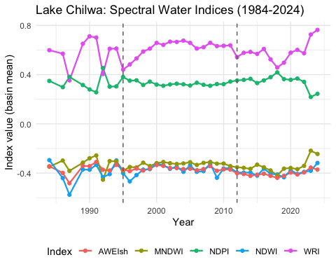
First, no single optical water index captures the full range of conditions that endorheic wetlands present. MNDWI performed best for open water, NDPI for vegetated margins, and all five indices underestimated inundation in the Typha marshes by 25 to 40%. SAR backscatter analysis addressed the specific failures of optical methods, providing continuous wet-season monitoring, detection of flooding beneath vegetation through double-bounce scattering, and gradient-based tracking of the recession-refilling wavefront. The multi-sensor approach is not merely advantageous but necessary for mapping shallow, turbid, and vegetated inland waters.
Second, population movement across the basin tracked water extent dynamics with a consistent 3-month anticipatory lag. Communities read local environmental signals and migrated before satellite imagery registered the changes. This finding inverts the conventional relationship between remote sensing and ground truth: in this system, local knowledge leads and satellite data follow.
Third, the fishery is governed by what Wilson, Russell, and Dobson (2008) call “a patchwork of traditional, modern, and post-modern regimes”: a layered system of traditional territorial claims, kinship obligations, and selective compliance that formal monitoring does not capture. Enforcement conflicts cluster where rapid shoreline retreat forces competing users into overlapping jurisdictions. These governance dynamics determined conservation outcomes more directly than any formal regulation, and were accessible only through sustained ethnographic fieldwork.
Fourth, the integration of remote sensing with ethnographic methods fills a gap that neither approach addresses alone. Remote sensing provides spatial and temporal coverage across decades; ethnographic fieldwork provides the social and institutional context that gives that coverage meaning. The two are complementary but not substitutable. Studies that rely solely on rapid participatory appraisal or structured surveys cannot reproduce the depth of understanding that extended immersion in fishing communities yields.
The socio-hydrological framework developed here is transferable. Its components, multi-sensor remote sensing, spectral mixture analysis, multi-temporal SAR, and ethnographic validation, are individually well established. Their integration for endorheic wetland monitoring is not. Lake Chilwa demonstrates that this integration produces findings inaccessible to either approach alone, and that the social dimensions of wetland dynamics are as consequential as the biophysical ones for conservation outcomes. By mapping the inundation history and the fisher response as a single coupled process, the study establishes the empirical basis for a socio-hydrological model of the Lake Chilwa water-society feedback, and sets that model as the next step toward a decision-relevant understanding of the basin (Srinivasan et al., 2017; Xia et al., 2022).
References
Acharya, T. D., Subedi, A., & Lee, D. H. (2018). Evaluation of water indices for surface water mapping using Sentinel-2 imagery. Sensors, 18(8), 2580.
Allison, E. H., & Mvula, P. M. (2002). Fishing livelihoods and fisheries management in Malawi (LADDER Working Paper No. 23). Overseas Development Institute.
Amani, M., Brisco, B., Afshar, M., Mirmazloumi, S. M., Mahdavi, S., Mirzadeh, S. M. J., Huang, W., & Granger, J. (2019). A generalized supervised classification scheme to produce provincial wetland inventory maps: An application of Google Earth Engine for big geo data processing. GIScience and Remote Sensing, 56(7), 1023-1045.
Amani, M., Mahdavi, S., Afshar, M., Brisco, B., Huang, W., Mirzadeh, S. M. J., White, L., Banks, S., Montgomery, J., & Hopkinson, C. (2020). Canadian wetland inventory using Google Earth Engine: The first map and preliminary results. Remote Sensing, 12(7), 1190.
Bene, C. (2003). When fishery rhymes with poverty: A first step beyond the old paradigm on poverty in small-scale fisheries. World Development, 31(6), 949-975.
Breiman, L. (2001). Random forests. Machine Learning, 45(1), 5-32.
Campos, J. C., Sillero, N., & Brito, J. C. (2012). Normalized difference water indexes have dissimilar performances in detecting seasonal and permanent water in the Sahara-Sahel transition zone. Journal of Hydrology, 464-465, 438-446.
Chirwa, W. C. (1996). Fishing rights, ecology and conservation along southern Lake Malawi, 1920-1964. African Affairs, 95(380), 351-377.
Chiotha, S. S. (1996). Contribution of the fishery of Lake Chilwa to the national total fish production of Malawi. In M. Kalk, A. J. McLachlan, & C. Howard-Williams (Eds.), Lake Chilwa: Studies of change in a tropical ecosystem (Monographiae Biologicae 35). Junk.
Clement, M. A., Kilsby, C. G., & Moore, P. (2018). Multi-temporal synthetic aperture radar flood mapping using change detection. Journal of Flood Risk Management, 11(2), 152-168.
COMPASS. (2004). Fisheries management policy by-laws: Legal toolbox for participative fisheries management in Malawi. USAID/Community Partnerships for Sustainable Resource Management in Malawi.
Crossley, R., Davison-Hirshmann, S., Owen, B., & Shaw, P. (1983). Lake level fluctuations during the last 2,000 years in Malawi. In SASQUA International Symposium, Swaziland (pp. 305-316).
Davidson, N. C. (2014). How much wetland has the world lost? Long-term and recent trends in global wetland area. Marine and Freshwater Research, 65(10), 934-941.
Del Rio, T., Groot, J. C. J., & DeClerck, F. (2018). Landscape ecological knowledge base for Barotse Floodplain, Zambia. Data in Brief, 19, 2297-2304.
Demelash, T., Gessesse, G. D., Alemu, M. L., & Tilahun, S. A. (2025). Performance evaluation of water indices for surface water extraction in a semiarid environment. H2Open Journal, 8(5), 402.
Demichelis, C., Pottier, P., & Thibault, M. (2023). Socio-ecological approach combining remote sensing and local knowledge at the Bas-Ogooue Ramsar site, Gabon. Unpublished manuscript.
Deus, D., & Gloaguen, R. (2013). Remote sensing analysis of lake dynamics in semi-arid regions. Remote Sensing, 5(12), 5765-5781.
Environmental Affairs Department. (2000). State of environment report for Malawi 2000. Ministry of Natural Resources and Environmental Affairs.
Feyisa, G. L., Meilby, H., Fensholt, R., & Proud, S. R. (2014). Automated water extraction index: A new technique for surface water mapping using Landsat imagery. Remote Sensing of Environment, 140, 23-35.
Finlayson, C. M., Davies, G. T., Moomaw, W. R., Chmura, G. L., Natali, S. M., Perry, J. E., Rber, N., & Sutton-Grier, A. E. (2018). The second state of the world’s wetlands and their services to people: A 2020 update. Wetland Science and Practice, 35(2), 1-18.
Fisher, A., Flood, N., & Danaher, T. (2016). Comparing Landsat water index methods for automated water classification in eastern Australia. Remote Sensing of Environment, 175, 167-177.
Freeman, T. G. (1991). Calculating catchment area with divergent flow based on a regular grid. Computers & Geosciences, 17(3), 413-422.
Gorelick, N., Hancher, M., Dixon, M., Ilyushchenko, S., Thau, D., & Moore, R. (2017). Google Earth Engine: Planetary-scale geospatial analysis for everyone. Remote Sensing of Environment, 202, 18-27.
Halabisky, M., Moskal, L. M., Gillespie, A., & Hannam, M. (2016). Reconstructing semi-arid wetland surface water dynamics through spectral mixture analysis of a time series of Landsat satellite images (1984-2011). Remote Sensing of Environment, 177, 171-183.
Hara, M., & Nielsen, J. (2003). Experiences with fisheries co-management in Africa. In D. Wilson, J. Nielsen, & P. Degnbol (Eds.), The fisheries co-management experience: Accomplishments, challenges and prospects (pp. 82-95). Kluwer Academic Publishers.
Hardy, A., Ettritch, G., Cross, D. E., Sheridan, S., Mason, D., Sherlock, R., Sherlock, M., Lopez, J., & Sherlock, N. (2019). Automatic detection of open and vegetated water bodies using Sentinel-1 to map African malaria vector mosquito breeding habitats. Remote Sensing, 11(6), 720.
Heimhuber, V., Tulbure, M. G., & Broich, M. (2018). Modelling 25 years of spatio-temporal surface water and inundation dynamics on large river basin scale using time series of Earth observation data. Remote Sensing of Environment, 209, 27-42.
Hess, L. L., Melack, J. M., & Simonett, D. S. (1995). Radar detection of flooding beneath the forest canopy: A review. IEEE Transactions on Geoscience and Remote Sensing, 33(4), 896-904.
Hess, L. L., Melack, J. M., Novo, E. M. L. M., Barbosa, C. C. F., & Gastil, M. (2003). Dual-season mapping of wetland inundation and vegetation for the central Amazon basin. Remote Sensing of Environment, 87(4), 404-428.
Hong, S.-H., & Wdowinski, S. (2017). Multitemporal multitrack monitoring of wetland water levels in the Florida Everglades using ALOS PALSAR data with interferometric processing. IEEE Geoscience and Remote Sensing Letters, 14(8), 1370-1374.
Huang, C., Peng, Y., Lang, M., Yeo, I.-Y., & McCarty, G. (2014). Wetland inundation mapping and change monitoring using Landsat and airborne LiDAR data. Remote Sensing of Environment, 141, 231-242.
Jamu, D., Chapotera, M., & Likongwe, J. (2003). Uncovering human social networks in coping with Lake Chilwa recessions. Journal of Environmental Management, 69, 1-8.
Ji, L., Zhang, L., & Wylie, B. (2009). Analysis of dynamic thresholds for the normalized difference water index. Photogrammetric Engineering and Remote Sensing, 75(11), 1307-1317.
Ji, L., Gong, P., Wang, J., Shi, J., & Zhu, Z. (2015). Construction of the 500-m resolution daily global surface water change database (2001-2015). International Journal of Applied Earth Observation and Geoinformation, 41, 109-117.
Kalanda-Sabola, M. D., Henry, E. M. T., Kambewa, E., & Saka, J. (2007). Use of indigenous knowledge and traditional practices in fisheries management: A case of Chisi Island, Lake Chilwa, Zomba. Malawi Journal of Science and Technology, 8, 53-66.
Kalk, M. (Ed.). (1979). Lake Chilwa: Studies of change in a tropical ecosystem (Monographiae Biologicae 35). Junk.
Kim, S., Wdowinski, S., Amelung, F., Dixon, T. H., & Won, J.-S. (2021). Interferometric coherence analysis of the Everglades wetlands, South Florida. Remote Sensing of Environment, 252, 112150.
Kolding, J., & van Zwieten, P. A. M. (2012). Relative lake level, water colour and fisheries productivity in fluctuating tropical lakes and reservoirs. Fisheries Research, 115-116, 99-109.
Lacaux, J. P., Tourre, Y. M., Vignolles, C., Ndione, J. A., & Lafaye, M. (2007). Classification of ponds from high-spatial resolution remote sensing: Application to Rift Valley Fever epidemics in Senegal. Remote Sensing of Environment, 106(1), 66-80.
Li, J., Wang, L., Liu, S., Peng, B., & Ye, H. (2023). An automated method for mapping surface water using Sentinel-2 imagery. Remote Sensing, 15(6), 1678.
Li, W., Du, Z., Ling, F., Zhou, D., Wang, H., Gui, Y., Sun, B., & Zhang, X. (2013). A comparison of land surface water mapping using the normalized difference water index from TM, ETM+ and ALI. Remote Sensing, 5(11), 5530-5549.
Lopes, S., Poisse, E., Wilson, J., Kromer, I., Manuel, C., Cululo, C., & Pinto, M. (1998). From no management towards co-management? A case study on artisanal fisheries in Angoche district, Nampula Province, Mozambique. In A. Normann, J. Nielsen, & S. Sverdrup-Jensen (Eds.), Proceedings of a regional workshop on fisheries co-management research (pp. 125-150). Institute for Fisheries Management.
Lubala, N., Kavwaya, Y., & Kalonda, D. (2023). Combining Sentinel-1, Sentinel-2, and ALOS PALSAR for mapping small inland wetlands in the Democratic Republic of Congo. Ecological Indicators, 155, 110962.
Luca, G., Marasco, A., & Balzano, L. (2025). Mapping seasonal inundation dynamics of the Okavango Delta using Sentinel-1 SAR time series. Remote Sensing of Environment, 310, 114474.
Mahdavi, S., Salehi, B., Granger, J., Amani, M., Brisco, B., & Huang, W. (2018). Remote sensing for wetland classification: A comprehensive review. Remote Sensing of Environment, 206, 1-21.
Mahdianpari, M., Salehi, B., Mohammadimanesh, F., & Motagh, M. (2017). Random forest wetland classification using ALOS-2 L-band, RADARSAT-2 C-band, and TerraSAR-X imagery. ISPRS Journal of Photogrammetry and Remote Sensing, 130, 13-31.
Mahdianpari, M., Salehi, B., Mohammadimanesh, F., Homayouni, S., & Gill, E. (2019). The first wetland inventory map of Newfoundland at a spatial resolution of 10 m using Sentinel-1 and Sentinel-2 data on the Google Earth Engine cloud computing platform. Remote Sensing, 11(1), 43.
Martinis, S., Twele, A., & Voigt, S. (2015). Towards operational near real-time flood detection using a split-based automatic thresholding procedure on high resolution TerraSAR-X data. Natural Hazards and Earth System Sciences, 15(5), 1069-1085.
McFeeters, S. K. (1996). The use of the normalized difference water index (NDWI) in the delineation of open water features. International Journal of Remote Sensing, 17(7), 1425-1432.
Mitsch, W. J., & Gosselink, J. G. (2015). Wetlands (5th ed.). Wiley.
Muro, J., Canty, M., Conradsen, K., Huttich, C., Nielsen, A. A., Skriver, H., Remy, F., Strauch, A., Thonfeld, F., & Menz, G. (2016). Short-term change detection in wetlands using Sentinel-1 time series. Remote Sensing, 8(10), 795.
Murphy, S. (2014). Contested meanings through social change: An ethnography of institutions, organisations, ideologies and power in the market development of the Lake Chilwa commons, southern Malawi [Doctoral dissertation, SOAS, University of London].
National Statistical Office. (2008). 2008 population and housing census: Main report. National Statistical Office, Zomba, Malawi.
Njaya, F. (2001). Review of fisheries and fish biology of Lake Chilwa. In D. Jamu, M. Chapotera, & J. Likongwe (Eds.), Lake Chilwa state of the environment report. Chancellor College.
Njaya, F. (2007). Governance challenges of the implementation of fisheries co-management: Experiences from Malawi. International Journal of the Commons, 1(1), 137-153.
Njaya, F. (2009). Governance of Lake Chilwa common pool resources: Evolution of institutions and user perceptions. Development Southern Africa, 26(4), 663-676.
Njaya, F., Snyder, K. A., Jamu, D., Wilson, J., Howard-Williams, C., Allison, E. H., & Andrew, N. L. (2011). The natural history and fisheries ecology of Lake Chilwa, southern Malawi. Journal of Great Lakes Research, 37(Suppl. 1), 15-25.
Njaya, F., Donda, S., & Bene, C. (2012). Analysis of power in fisheries co-management: Experiences from Malawi. Society and Natural Resources, 25(4), 332-346.
Nunan, F. (2015). Wealth and welfare? Can fisheries management succeed in achieving multiple objectives? A case study of Lake Victoria, East Africa. World Development, 70, 203-214.
Ostrom, E. (2009). A general framework for analyzing sustainability of social-ecological systems. Science, 325(5939), 419-422.
Pekel, J.-F., Cottam, A., Gorelick, N., & Belward, A. S. (2016). High-resolution mapping of global surface water and its long-term changes. Nature, 540(7633), 418-422.
Peters, P. E. (2006). Rural income and poverty in a time of radical change in Malawi. Journal of Development Studies, 42(2), 322-345.
Quinn, P., Beven, K., Chevallier, P., & Planchon, O. (1991). The prediction of hillslope flow paths for distributed hydrological modelling using digital terrain models. Hydrological Processes, 5(1), 59-79.
Rebelo, L.-M., Finlayson, C. M., & Nagabhatla, N. (2009). Remote sensing and GIS for wetland inventory, mapping and change analysis. Journal of Environmental Management, 90(7), 2144-2153.
Roth, F., Bauer-Marschallinger, B., Tupas, M. E., & Wagner, W. (2025). The Sentinel-1 Global Flood Monitoring system. Remote Sensing of Environment, 310, 114493.
Sarch, M. T., & Allison, E. H. (2000). Fluctuating fisheries in Africa’s inland waters: Well adapted livelihoods, maladapted management. In Proceedings of the 10th Biennial Conference of the International Institute of Fisheries Economics and Trade. IIFET.
Seibert, J., & McGlynn, B. L. (2007). A new triangular multiple flow direction algorithm for computing upslope areas from gridded digital elevation models. Water Resources Research, 43(4), W04501.
Shanmugam, P., Ahn, Y.-H., & Sanjeevi, S. (2006). A comparison of the classification of wetland characteristics by linear spectral mixture modelling and traditional hard classifiers on multispectral remotely sensed imagery in southern India. Ecological Modelling, 194(4), 379-394.
Shen, L., & Li, C. (2010). Water body extraction from Landsat ETM+ imagery using adaboost algorithm. In Proceedings of the 18th International Conference on Geoinformatics (pp. 1-4). IEEE.
Tarboton, D. G. (1997). A new method for the determination of flow directions and upslope areas in grid digital elevation models. Water Resources Research, 33(2), 309-319.
Tarboton, D. G. (2015). TauDEM 5.3: Terrain Analysis Using Digital Elevation Models. Utah State University. https://hydrology.usu.edu/taudem/
Tozer, B., Sandwell, D. T., Smith, W. H. F., Olson, C., Beale, J. R., & Wessel, P. (2019). Global bathymetry and topography at 15 arc sec: SRTM15+. Earth and Space Science, 6(10), 1847-1864.
Tsyganskaya, V., Martinis, S., Marzahn, P., & Ludwig, R. (2018). SAR-based detection of flooded vegetation: A review of characteristics and approaches. International Journal of Applied Earth Observation and Geoinformation, 73, 205-218.
Wdowinski, S., Kim, S.-W., Amelung, F., Dixon, T. H., Miralles-Wilhelm, F., & Sonenshein, R. (2008). Space-based detection of wetlands’ surface water level changes from L-band SAR interferometry. Remote Sensing of Environment, 112(3), 681-696.
Whyte, A., Ferentinos, K. P., & Petropoulos, G. P. (2018). A new synergistic approach for monitoring wetlands using Sentinels-1 and 2 data with object-based machine learning algorithms. Environmental Modelling and Software, 104, 40-54.
Wilson, J. G. M. (2007). The waterfowl of Lake Chilwa and their utilisation by local communities, and conservation measures as required by the Ramsar Convention. Lake Chilwa Wetland Project.
Wilson, J. G. M. (2008). Fisheries management in Malawi: A patchwork of traditional, modern, and post-modern regimes unfolds. In R. M. Hughes, L. Wang, & P. W. Seelbach (Eds.), Landscape influences on stream habitats and biological assemblages (American Fisheries Society Symposium 62). American Fisheries Society. (With A. Russell & T. Dobson)
Wilson, J. G. M. (2009). Lake Chilwa and Mpoto Lagoon fisheries management plan. Government of Malawi, Ministry of Agriculture. Unpublished.
Wilson, J. (2010). The people of the lake and basin. Unpublished manuscript, Zomba.
Wilson, J. (2014). The history of the level of Lake Chilwa. The Society of Malawi Journal, 67(2), 41-45.
Woodward, K., Marti-Cardona, B., & Oberg, J. (2021). Integrating participatory mapping with remote sensing for wetland conservation. Remote Sensing, 13(5), 890.
Xu, H. (2006). Modification of normalised difference water index (NDWI) to enhance open water features in remotely sensed imagery. International Journal of Remote Sensing, 27(14), 3025-3033.
Xu, Y., Liu, Y., & Liu, S. (2025). Mapping surface water dynamics across East Africa at 10 m resolution by integrating Sentinel-1 and Sentinel-2 time series. ISPRS Journal of Photogrammetry and Remote Sensing, 215, 101-118.
Yiran, G. A. B., Kusimi, J. M., & Kufogbe, S. K. (2012). A synthesis of remote sensing and local knowledge approaches in land degradation assessment in the Bawku East District, Ghana. International Journal of Applied Earth Observation and Geoinformation, 14(1), 204-213.
Zebker, H. A., & Villasenor, J. (1992). Decorrelation in interferometric radar echoes. IEEE Transactions on Geoscience and Remote Sensing, 30(5), 950-959.
Zhang, G., Yao, T., Chen, W., Zheng, G., Shum, C. K., Yang, K., Peng, S., Tian, Y., Shang, Y., & Zhang, S. (2019). Regional differences of lake evolution across China during 1960s-2015 and its natural and anthropogenic causes. Science of the Total Environment, 655, 1390-1401.